
For our next climb, my wife and I decided to try Gunung Datuk in Rembau, Negeri Sembilan some 100 kilometers south of Kuala Lumpur. Getting there is straight forward and easy enough via PLUS highway and exit at the Pedas-Linggi toll. For the rest of the direction, consult your trusty Google Maps or Waze app :).

At the entrance, you'll find this parking lot and ranger's office with some basic facilities like restrooms and eateries. And of course you can't miss the huge keris replica at the entrance since malays and keris are inseparable.

After parking your car nicely (make sure you don't block anybody else), proceed to the counter to register and pay the 5 ringgit entrance fee. You may then proceed to climb the hill at the back of the office where you'll meet a little stream and pool first where people go for a dip after a tiring climb.

According to this notice board you must follow several rules like hiking at designated times, getting a guide for a group of 10 or more and no camping anywhere on the hill. To be honest, most people decided to ignore those rules because I can see traces of campsite and no guides in sight. I doubt people need guides anyway because this hike is like so easy and the routes are pretty worn and straightforward.


Overall I must rate Gunung Datuk as relatively easy. It's a gradual climb all the way to the top with loads of tree roots and little rocks and ropes to help you climb.

There's supposed to be a few huts or wakaf along the way for you to rest but we can only see one which only has the roof left. Talk about bad management. I wonder whatever they do with all the money collected.

We did saw a lot of huge rocks and boulders some are more than 20 feet tall.

This is the well used camp site at the top of the hill.


At 870 meters, Gunung Datuk still poses a little bit of challenge to beginners and the like. For the more experienced hikers though, it'll be quite easy.
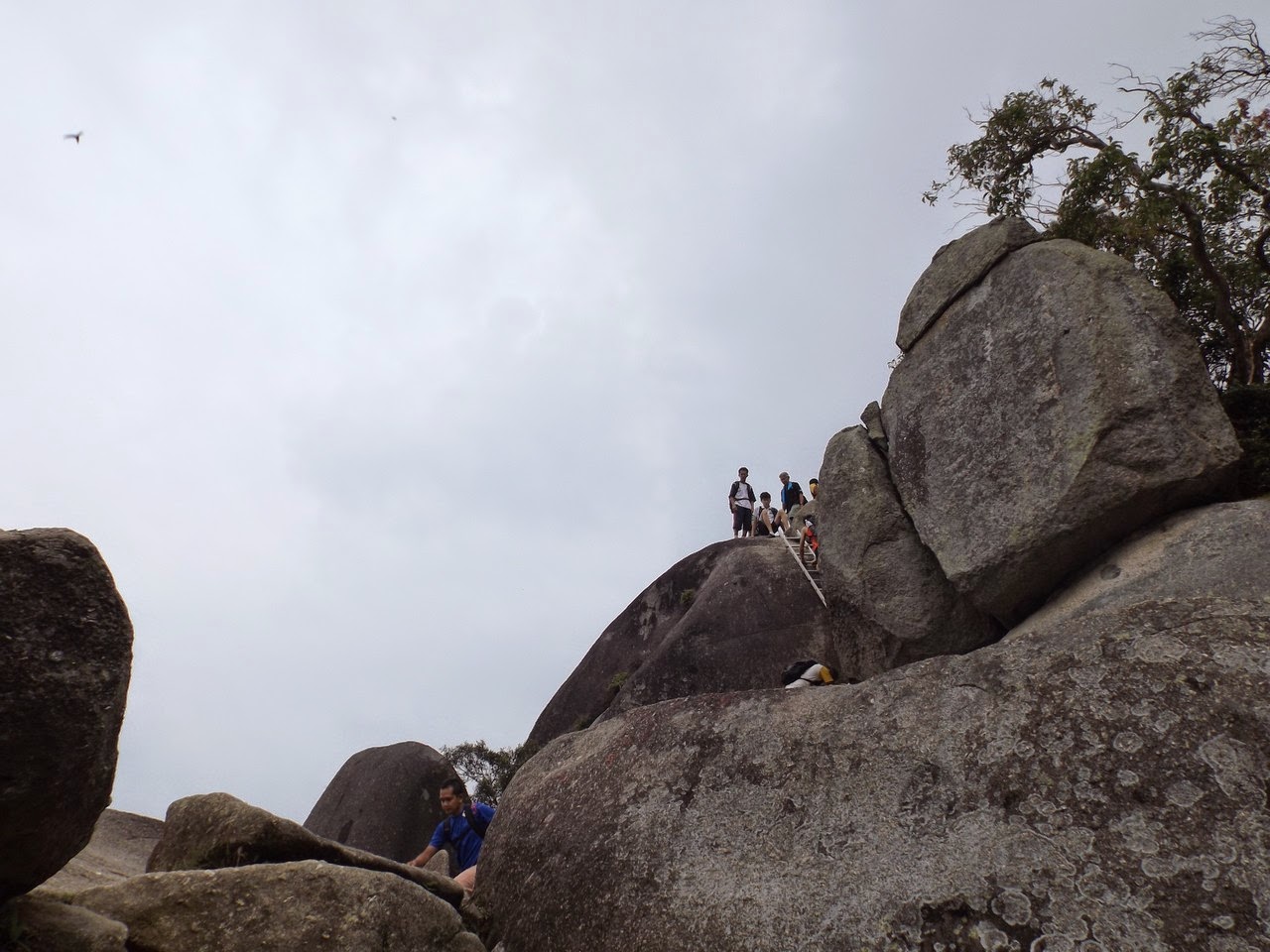
Like I said, there's plenty of huge boulders around the hill including some at the top. To reach the peak, you'll have to climb 3 set of ladders which was easy at first butt can be quite scary in the end, especially the last one.

At the peak, we were rewarded with a breathtaking view of the surrounding area and hills. On a clear day, you can see all the way to the Straits of Malacca.

But it was not our lucky day because it was hazy all the way and we can't see much except the adjacent hills.

There you can see a little hole on the rock, probably a random depression caused by the weather or some erosion. To the locals or the superstitious lot, they'll tell you it's the foot print of local legend Hang Tuah.

In a nut shell, Gunung Datuk is a relatively easy hill to climb even for beginners. We finished our way up in about 2 hours flat. As always make adequate preparation and bring enough supplies especially water and do a little bit of training or exercise before embarking on any type of climb or hike.
View Gunung Datuk Rembau in a larger map
This comment has been removed by the author.
ReplyDeleteHi Afif,
ReplyDeletenice to come across your blog post as I am interested to hike Gn Datuk.
in the 2nd picture of the pool/stream area, do we climb the stairs or we head to the right (where the rocks and people are seating)? Is this pool/stream before the bridge?
wow! 800m over in altitude! Keeping this too in my bucket list!
ReplyDelete